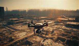
Tech in Disaster Management: Saving Lives with Drones and Data.
As climate change and urbanization amplify the frequency and impact of disasters, technology is transforming how we respond. Drones provide real-time visuals and access to unreachable zones, while data analytics enable precise forecasting and efficient resource deployment. Together, these innovations are revolutionizing disaster management, enhancing preparedness, accelerating rescue efforts, and ultimately saving countless lives across the globe.
✨ Raghav Jain
Introduction: The Changing Face of Disasters
Disasters—whether natural like earthquakes, hurricanes, and wildfires, or man-made such as industrial accidents and terrorist attacks—strike with little warning, causing massive devastation. In such crises, time is the most precious resource. Traditional methods of disaster management often struggle with speed, accuracy, and communication gaps. Enter technology: a game-changer that is dramatically reshaping how we prepare for, respond to, and recover from disasters.
Technological innovations, particularly drones and data-driven systems, are revolutionizing every phase of disaster management. These tools are being used to assess damage, locate survivors, deliver aid, predict events, and coordinate rescue efforts with unprecedented precision and efficiency.
The Role of Drones in Disaster Response (Approx. 1000 Words)
Drones, or Unmanned Aerial Vehicles (UAVs), have become indispensable in disaster zones for several reasons: they are fast, cost-effective, and can access areas that are otherwise unreachable by foot or vehicle. These flying devices have proven their value repeatedly in recent global catastrophes.
1. Search and Rescue Operations
After an earthquake or flood, roads are often destroyed, and survivors may be trapped under debris or stranded in remote locations. Drones equipped with thermal imaging cameras can scan large areas quickly and identify heat signatures, helping first responders locate survivors faster than traditional methods.
In the 2015 Nepal earthquake, drones were used to map damaged areas and assist search and rescue teams. Similarly, in hurricanes Harvey and Irma in the United States, drones scouted flooded neighborhoods to identify people in need of help.
2. Rapid Damage Assessment
Assessing the extent of damage is vital for effective disaster response. High-resolution aerial images captured by drones provide detailed insights into infrastructure damage, enabling authorities to allocate resources wisely. These maps also assist insurance companies and aid agencies in estimating financial losses and planning recovery strategies.
For instance, after wildfires in California, drone footage was used to create 3D models of affected regions, helping officials to evaluate the environmental impact and plan reconstruction.
3. Delivery of Essential Supplies
In areas where roads are blocked or dangerous, drones are being deployed to deliver food, water, medical kits, and even defibrillators. Zipline, a drone delivery company, has been providing medical supplies to remote villages in Rwanda and Ghana. This model is now being explored for disaster zones worldwide.
During the COVID-19 pandemic, drones delivered vaccines and PPE to isolated regions, minimizing human contact and speeding up distribution.
4. Monitoring and Early Warning
Equipped with sensors and cameras, drones can monitor volcanic activity, landslides, or rising floodwaters in real-time. This information helps local governments issue timely evacuation orders and prepare emergency shelters.
For example, Japan uses drones to monitor volcanic mountains, providing early alerts to nearby populations. In India, during the 2020 floods in Assam, drones helped identify breaches in embankments, allowing quick repairs to minimize flooding.
5. Post-Disaster Recovery
Drones continue to play a role even after the initial emergency has passed. They help in infrastructure rebuilding, environmental assessment, and monitoring displaced populations. Continuous aerial monitoring can also prevent secondary disasters, such as disease outbreaks or structural collapses in weakened buildings.
The Power of Data in Disaster Management (Approx. 1000 Words)
While drones provide the "eyes in the sky," data provides the "brains on the ground." From AI algorithms predicting earthquakes to satellite data detecting cyclone patterns, the role of big data and analytics in disaster management is profound.
1. Predictive Analytics
Advanced modeling and AI can forecast the likelihood and impact of disasters. Machine learning algorithms analyze historical patterns, weather models, and real-time data to predict events such as floods, storms, and wildfires.
For instance, IBM’s Watson can process vast weather datasets and predict the development of hurricanes with high accuracy. Similarly, Google AI is being used in India to provide flood forecasting alerts via mobile phones, potentially saving millions of lives.
2. Early Warning Systems
Early warning is one of the most effective ways to reduce disaster casualties. Data from satellites, sensors, and historical records are combined to trigger automated warnings. These alerts are disseminated through SMS, radio, television, and mobile apps.
Japan's Earthquake Early Warning system uses real-time seismic data to alert citizens seconds before tremors arrive, allowing people to take cover. In Bangladesh, community-based flood warning systems have been enhanced using real-time river data.
3. Crisis Mapping and Real-Time Tracking
During a disaster, data collected from drones, social media, GPS, and sensors is visualized on digital maps that guide rescue teams. Platforms like Ushahidi, Humanitarian OpenStreetMap, and GIS (Geographic Information System) tools provide real-time situational awareness.
These technologies were instrumental in coordinating responses during the Haiti earthquake and the Ebola outbreak in West Africa. Crisis maps showed affected zones, resource centers, and safe routes for evacuations.
4. Resource Allocation and Logistics
Big data helps authorities understand where to send resources—medical teams, food, fuel—based on severity and need. AI-powered logistics systems optimize routes for delivering aid, especially in chaotic and infrastructure-damaged environments.
UNICEF has used data-driven logistics to plan vaccine distributions during health emergencies. Similarly, the Red Cross utilizes AI algorithms to assess where shelters, water, and medical care are needed the most.
5. Crowdsourced Data and Social Media
In today's connected world, people on the ground often report incidents faster than official sources. Platforms like Twitter and Facebook are monitored using natural language processing to identify distress calls and emerging threats.
For instance, during Hurricane Sandy, social media data helped pinpoint flooded areas and people needing urgent help. Crisis responders now rely on a mix of official data and user-generated content to make better decisions.
6. Post-Disaster Analysis and Policy Making
After the disaster, data analytics help evaluate the response—what worked, what failed, and how to improve. This information informs policies, urban planning, and disaster preparedness drills.
Governments use post-disaster data to update building codes, design flood-resistant infrastructure, and enhance healthcare systems for future resilience.
In an age marked by increasingly frequent and severe natural and man-made disasters, technology has emerged as both a shield and a sword in the battle for survival and resilience, with drones and data analytics proving to be among the most revolutionary tools in modern disaster management. These technological advancements are not only transforming how first responders and governments react to emergencies but are also redefining how societies prepare for, mitigate, and recover from crises. Drones, or unmanned aerial vehicles (UAVs), have found their place high above the chaos, providing bird’s-eye views of flood zones, collapsed buildings, forest fires, and disaster-struck regions, often acting as the first "eyes" on the scene when access for humans is limited or impossible. Their utility spans multiple critical areas: rapid damage assessment, search and rescue operations, supply delivery, and real-time situational monitoring. With high-resolution cameras and thermal imaging sensors, drones can detect body heat through rubble, locating trapped survivors far more efficiently than manual methods. During the 2015 Nepal earthquake, for example, drones equipped with such capabilities scouted inaccessible mountain villages, guiding rescue operations and mapping devastated areas in record time. In the United States, drones have been instrumental during hurricanes like Harvey and Irma, flying over floodwaters to identify stranded individuals, assess structural damage, and guide emergency boats to exact locations, saving countless lives. Beyond immediate response, drones also support long-term recovery, helping engineers monitor critical infrastructure such as dams, power lines, and bridges for latent damage. Meanwhile, the data collected from drones feeds directly into disaster management systems powered by artificial intelligence (AI), big data, and predictive analytics. These systems leverage historical disaster data, real-time weather updates, and environmental conditions to generate simulations and risk models, offering insights not just into what has happened but what could happen next. Early warning systems built on such data are now capable of providing alerts for floods, cyclones, landslides, and wildfires hours or even days in advance, giving authorities and civilians precious time to evacuate or prepare. For example, Google’s AI flood forecasting system in India has alerted millions to rising river levels, saving countless lives and minimizing property loss. In Japan, a country with a sophisticated earthquake monitoring system, predictive analytics combined with seismic sensors provide early alerts to citizens via mobile phones, giving them critical seconds to duck for cover or stop trains, preventing derailments. Similarly, in Bangladesh, where flooding is an annual challenge, predictive data models based on rainfall, river data, and satellite imaging have improved warning accuracy, empowering villagers to take early action. The impact of data goes beyond prediction and response—it helps map out crisis zones in real time. Geographic Information Systems (GIS), satellite imagery, and real-time drone footage are combined to create live crisis maps that emergency teams, humanitarian organizations, and governments use to coordinate their response, ensuring that help reaches where it’s needed most. Tools like Humanitarian OpenStreetMap and platforms like Ushahidi crowdsource data from people on the ground—social media posts, SMS updates, GPS-tagged reports—creating a living, evolving map of disaster impact zones, blocked roads, functional hospitals, and safe zones. This data-driven approach helps optimize the deployment of limited resources—emergency crews, food supplies, medical aid—making disaster response not just faster but smarter. Additionally, data analytics improve the efficiency of supply chains and logistics. Humanitarian organizations like the Red Cross or UNICEF use AI algorithms to forecast the most effective delivery routes for emergency supplies, taking into account blocked roads, weather conditions, and population density. In regions like sub-Saharan Africa and parts of Asia, companies like Zipline have taken this a step further by using drones to deliver vaccines, blood, and medicine to remote and disaster-hit areas where ground access is not viable. During the COVID-19 pandemic, such drone delivery systems were adapted to distribute personal protective equipment and test kits, reducing human contact and ensuring equitable reach. The convergence of data and drone technology is also playing a critical role in post-disaster reconstruction. Authorities use drone footage to assess the structural integrity of buildings and plan for reconstruction. Environmental scientists monitor the secondary impacts of disasters—such as water contamination or landslide risks—while urban planners and engineers use data models to design more resilient infrastructure. The benefits of this technological shift aren’t limited to governments or international agencies; communities are now more involved in their own protection through mobile apps, SMS alerts, and community-driven warning systems. This decentralization of disaster intelligence empowers local populations to act faster and with greater autonomy. However, as promising as this technological evolution is, it also comes with challenges—privacy concerns, regulatory hurdles, the need for skilled operators, and the digital divide that limits access in low-income or remote areas. Drones require airspace clearance, and misuse could lead to safety issues or security threats. Similarly, data-driven systems require stable internet, electricity, and trained personnel to function optimally—luxuries that might be lacking in the most disaster-prone regions. Despite these limitations, the trajectory is clear: technology is not a mere supplement but an essential component of modern disaster management. Global initiatives, such as the United Nations Office for Disaster Risk Reduction’s promotion of tech-based resilience, and the growing partnerships between governments, tech firms, and humanitarian organizations, underline the importance of continuing innovation. As artificial intelligence becomes more sophisticated, and drone hardware becomes cheaper and more accessible, we can expect even greater integration of these tools into local, national, and global disaster preparedness strategies. Imagine a future where AI predicts landslides days in advance, drones automatically deploy to pre-marked safe zones, and mobile apps guide citizens with personalized evacuation instructions—all within a globally connected emergency network. In this future, the suffering and loss caused by disasters will not disappear, but they will be significantly mitigated. The union of drones and data is not just a technological advancement—it is a humanistic one, making our world safer, faster to respond, and more compassionate in times of crisis.
In an increasingly unpredictable world where natural disasters such as earthquakes, tsunamis, floods, hurricanes, and wildfires strike with greater frequency and intensity—compounded further by man-made crises like industrial accidents, terrorist attacks, and pandemics—the role of technology in disaster management has grown from being an auxiliary support system to an indispensable life-saving necessity, with drones and data-driven technologies emerging at the forefront of this transformation; these tools not only improve response times and resource allocation but also provide real-time intelligence, situational awareness, and predictive analysis that are reshaping the very architecture of disaster response and recovery systems across the globe. Drones, also known as Unmanned Aerial Vehicles (UAVs), are now widely used to access disaster-stricken areas that are otherwise unreachable by foot or vehicle, especially in the critical "golden hours" immediately following a calamity, when the chances of saving lives are highest; equipped with high-definition cameras, thermal imaging sensors, and LiDAR technology, drones can scan vast territories quickly, identify survivors trapped beneath rubble using heat signatures, and transmit live visuals to emergency command centers, drastically reducing the time it takes to plan and execute rescue operations. For example, in the aftermath of the 2015 Nepal earthquake, drones played a pivotal role in mapping out collapsed buildings, identifying roadblocks, and guiding rescuers to otherwise hidden villages; similarly, during the devastating hurricanes Harvey and Irma in the United States, drones flew over flooded neighborhoods to locate stranded individuals, inspect damage, and assist in prioritizing the delivery of aid to the most affected regions. Moreover, drones are increasingly used to deliver critical supplies such as food, water, vaccines, medical kits, and even automated defibrillators to inaccessible or high-risk zones, minimizing human exposure while ensuring timely assistance; during the COVID-19 pandemic, for instance, drones helped transport test kits and PPE to remote areas, exemplifying how aerial technology can maintain continuity of care even under extreme lockdown or quarantine conditions. Beyond emergency response, drones contribute significantly to the recovery and rehabilitation phases by conducting detailed damage assessments, creating 3D models of terrain changes, and monitoring structural weaknesses in buildings, bridges, and dams, thereby informing the reconstruction strategy and preventing future hazards. While drones offer the "eyes in the sky," the power of data provides the "brain on the ground," and together, they form a symbiotic ecosystem of intelligence and action that is at the heart of modern disaster resilience; data-driven platforms powered by artificial intelligence, machine learning, and big data analytics are increasingly used to predict, prevent, and prepare for disasters before they occur, offering a level of foresight previously thought unattainable. Predictive modeling systems analyze vast quantities of historical and real-time data—including satellite imagery, weather patterns, seismic activity, and river flow rates—to forecast potential threats with remarkable accuracy; for instance, Google’s flood forecasting initiative in India, in partnership with local authorities, has successfully sent out millions of alerts via smartphones to residents living in flood-prone areas, giving them enough time to evacuate or prepare, thus significantly reducing loss of life and property. Similarly, Japan’s Earthquake Early Warning (EEW) system utilizes seismic sensors across the country to provide alerts mere seconds before tremors hit, allowing people to seek cover, halt surgeries, or stop trains, actions that can mean the difference between life and death. In addition, Geographic Information Systems (GIS) and real-time data visualization platforms such as Humanitarian OpenStreetMap and Ushahidi enable dynamic mapping of disaster zones, showing first responders the locations of collapsed buildings, blocked roads, operational hospitals, relief centers, and safe evacuation routes; this data often integrates crowd-sourced information from social media platforms like Twitter and Facebook, where residents post real-time updates, images, or pleas for help, which are then analyzed using natural language processing algorithms to identify urgent needs and crisis hotspots. In this way, disaster response becomes a two-way interaction between authorities and affected communities, enabling more efficient coordination and engagement. Data analytics also streamline the logistics of delivering aid, helping humanitarian organizations optimize routes for trucks, helicopters, and drones by taking into account terrain conditions, traffic, weather, and the evolving needs of disaster victims; agencies like UNICEF and the Red Cross now employ AI models to track resource consumption, anticipate shortages, and pre-position supplies before disasters even strike. Post-disaster, the collected data is invaluable for forensic analysis—what went wrong, what worked, and how to improve future responses—feeding into policy reforms, urban planning, infrastructure standards, and community preparedness programs; for example, flood risk maps derived from satellite data have influenced building codes and zoning laws in vulnerable regions, ensuring that future housing developments are better protected. Furthermore, emerging technologies like the Internet of Things (IoT) and blockchain are being integrated into disaster management systems to enhance transparency, security, and efficiency; IoT sensors monitor environmental indicators such as soil moisture, air quality, and water levels, triggering automatic alerts in case of anomalies, while blockchain ensures transparent tracking of donations, aid distribution, and relief funding, reducing corruption and improving accountability. The future of disaster management lies in the seamless integration of these diverse technologies into a unified digital command framework capable of intelligent, autonomous, and adaptive decision-making—imagine a scenario where drones autonomously deploy from charging stations the moment a tremor is detected, relaying live feeds to AI systems that instantly assess damage and deploy relief drones, while individuals receive personalized alerts on their smartphones with evacuation instructions based on their location, mobility, and risk exposure. However, this future is not without challenges; regulatory restrictions on drone flights, data privacy concerns, cybersecurity risks, the need for robust infrastructure, and the digital divide in low-income regions are all hurdles that need careful navigation; for instance, in some disaster-prone countries, lack of internet connectivity or digital literacy may prevent communities from benefiting from early warning apps or real-time maps. Still, the trajectory is promising, as governments, NGOs, academia, and tech companies continue to collaborate on pilot projects, invest in infrastructure, and conduct capacity-building programs to democratize access to these tools. Ultimately, the convergence of drones and data is more than just a technological leap—it is a humanitarian evolution that emphasizes speed, precision, inclusivity, and resilience in the face of nature’s fury, ensuring that every second saved, every life preserved, and every home rebuilt is a testament to the power of innovation in service of humanity.
Conclusion
Technology has moved from being a supportive tool to a frontline necessity in disaster management. Drones provide rapid assessment, assist in rescue, and offer delivery of essential supplies in hazardous areas. At the same time, data analytics and AI are empowering governments and humanitarian organizations to make proactive, real-time, and informed decisions that save lives.
The integration of drones and data is not just a trend—it’s a transformation. The synergy of these technologies is creating a future where disasters may still occur, but their human and economic toll can be dramatically reduced. As investment in these technologies grows and access becomes more widespread, the hope is to democratize disaster resilience globally.
Q&A Section
Q1:- What role do drones play in disaster management?
Ans:- Drones are used for search and rescue, damage assessment, delivering aid, and monitoring disaster zones. They offer a fast, safe, and cost-effective way to gather crucial information in real time.
Q2:- How does data help predict disasters?
Ans:- Predictive analytics and AI use historical data, weather patterns, and real-time sensor inputs to forecast disasters such as floods, hurricanes, and wildfires, enabling early warnings and preparedness.
Q3:- Can drones deliver supplies in emergencies?
Ans:- Yes, drones can deliver food, water, vaccines, and medical kits in inaccessible areas during emergencies, especially when roads are blocked or unsafe.
Q4:- How is social media used in disaster response?
Ans:- Social media platforms provide real-time updates and distress signals from people on the ground. Authorities use these crowdsourced reports to improve situational awareness and response coordination.
Q5:- What are some successful examples of tech in disaster management?
Ans:- Examples include drone mapping during the Nepal earthquake, AI-powered flood alerts in India by Google, and Zipline’s medical deliveries in Africa. These have all improved rescue efforts and minimized casualties.
Similar Articles
Find more relatable content in similar Articles
Digital DNA: The Ethics of Gen..
Digital DNA—the digitization a.. Read More

Protecting Kids in the Digital..
In an increasingly connected w.. Read More
Data Centers and the Planet: M..
As cloud computing becomes the.. Read More
Wearable Health Sensors: The D..
Wearable health sensors are re.. Read More
Explore Other Categories
Explore many different categories of articles ranging from Gadgets to Security
Smart Devices, Gear & Innovations
Discover in-depth reviews, hands-on experiences, and expert insights on the newest gadgets—from smartphones to smartwatches, headphones, wearables, and everything in between. Stay ahead with the latest in tech gear
Apps That Power Your World
Explore essential mobile and desktop applications across all platforms. From productivity boosters to creative tools, we cover updates, recommendations, and how-tos to make your digital life easier and more efficient.
Tomorrow's Technology, Today's Insights
Dive into the world of emerging technologies, AI breakthroughs, space tech, robotics, and innovations shaping the future. Stay informed on what's next in the evolution of science and technology.
Protecting You in a Digital Age
Learn how to secure your data, protect your privacy, and understand the latest in online threats. We break down complex cybersecurity topics into practical advice for everyday users and professionals alike.
© 2025 Copyrights by rTechnology. All Rights Reserved.