Tracking Birds with Tech: Migration Patterns Revealed by Satellites.
Exploring how advanced satellite technology has revolutionized the study of bird migration, enabling researchers to track precise routes, flight behaviors, and environmental interactions of migratory birds worldwide. This breakthrough has uncovered astonishing endurance feats, informed critical conservation efforts, and revealed the impact of climate change and human activities on migration patterns. Satellite tracking offers vital data for protecting global biodiversity and fostering.
✨ Raghav Jain
Introduction
Bird migration has fascinated humans for centuries. The sight of flocks crossing vast oceans, deserts, and mountain ranges prompts deep questions about animal instinct, endurance, and survival. While traditional bird tracking methods such as banding and visual observation have provided valuable data, they often fell short in scope and detail. Enter the digital age — where advanced satellite tracking technology has revolutionized our understanding of bird migration patterns across the globe.
The Evolution of Bird Tracking
Historically, bird migration was studied using rudimentary tools. Banding (or ringing) birds with unique tags allowed researchers to identify individual birds when they were later recaptured or found. Although useful, this method had limitations: it relied on chance encounters and provided sparse data points.
With the advent of radio telemetry in the mid-20th century, scientists could attach small transmitters to birds. These transmitters emitted signals picked up by ground-based receivers. While an improvement over banding, radio telemetry was labor-intensive and limited in range, often unsuitable for studying long-distance migrations.
The turning point came with satellite telemetry in the late 20th century, powered by systems like ARGOS and GPS-based technologies. For the first time, scientists could monitor birds continuously, regardless of terrain or remoteness, yielding rich, high-resolution data on their migratory behavior.
How Satellite Tracking Works
Satellite tracking involves attaching a lightweight transmitter, known as a GPS or PTT (Platform Transmitter Terminal), to a bird. These devices gather location data via satellites and relay the information to ground stations or databases accessible by researchers.
There are two primary systems:
- GPS Tags: These use the Global Positioning System to obtain accurate location data, often within a few meters.
- ARGOS System: Developed by CNES (France) and NOAA (USA), this system uses Doppler shifts in transmitted signals to calculate the position of animals.
Modern tracking tags can also record altitude, speed, temperature, and even heart rate, depending on the device.
Battery life and weight are major considerations, especially for small birds. Innovations such as solar-powered tags and miniaturized electronics have expanded the range of species that can be tracked without hampering their natural behavior.
Revealing Hidden Journeys
Satellite tracking has uncovered remarkable insights into bird migration patterns, many of which were previously unknown or misunderstood.
1. Arctic Terns – Champions of Distance
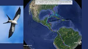
The Arctic Tern holds the record for the longest migration of any bird. Tracking studies have revealed that these birds travel from the Arctic to the Antarctic and back each year — a round-trip journey exceeding 70,000 kilometers. The terns navigate with astonishing precision and even take detours to exploit favorable wind currents, highlighting the complexity of their travel strategies.
2. Bar-tailed Godwits – Nonstop Flyers
In one of the most impressive examples of endurance, satellite-tracked Bar-tailed Godwits have been observed flying more than 12,000 kilometers non-stop from Alaska to New Zealand. These birds spend up to nine days in continuous flight without food or rest. Such data challenges existing ideas about physiological limits in birds.
3. Ospreys and Other Raptors
Ospreys, tracked from North America and Europe, have helped scientists understand the impact of geography on migratory routes. For example, many birds avoid large expanses of water, favoring routes with thermal air currents to assist soaring. Satellite data has shown how birds adapt their flight paths to weather, terrain, and seasonal cues.
4. Shorebirds and Climate Change
Tracking studies have shown that some species of shorebirds are adjusting their migratory timing in response to climate change. Earlier spring arrivals and shifts in wintering grounds signal the birds’ response to changes in temperature and food availability. These shifts have significant implications for conservation and ecological planning.
Conservation and Ecological Impact
Satellite tracking isn’t just about satisfying scientific curiosity. The data collected has immense practical value for conservation biology and habitat protection.
- Identifying Critical Stopover Sites: Many migratory birds rely on specific wetlands, forests, or coastal areas for rest and refueling. Satellite tracking helps identify these crucial locations, guiding conservation efforts and policy decisions.
- Monitoring Illegal Hunting and Poaching: Real-time tracking data can detect abnormal behavior — such as sudden immobility — which may indicate poaching. Authorities can use this information to intervene or increase surveillance in high-risk areas.
- Assessing Human Impact: Tracking allows researchers to see how human activities like urbanization, deforestation, and wind turbine development intersect with migratory paths. Such insights inform mitigation strategies and the development of "bird-friendly" infrastructure.
Challenges in Satellite Tracking
Despite its power, satellite tracking of birds presents some challenges:
- Cost: High-quality GPS transmitters and satellite subscriptions are expensive, limiting large-scale deployment.
- Size and Weight: While technology continues to shrink, very small birds still cannot be tracked easily without impacting their flight.
- Data Gaps: Satellites cannot always provide continuous data in regions with weak signal coverage or due to power limitations of devices.
Nonetheless, researchers continue to innovate, exploring next-gen solutions like AI-assisted modeling, drone-assisted observation, and networked sensor systems.
The Role of Citizen Science and Big Data
Many satellite tracking projects now integrate citizen science. Platforms like Movebank and eBird enable bird enthusiasts to contribute sightings, compare migration maps, and even track individual birds online. This democratization of data boosts public awareness and engagement in conservation.
Machine learning and big data analytics are increasingly used to analyze the vast amounts of migration data. By recognizing patterns and anomalies, AI helps predict shifts in migration routes due to environmental change, offering a powerful tool for proactive wildlife management.
Future Prospects
The future of bird tracking is bright and brimming with potential. Emerging technologies may soon allow:
- Real-time global coverage through low-orbit satellite constellations (e.g., Starlink).
- Energy harvesting from bird movement, reducing reliance on solar panels.
- Micro-robotics for tracking even the smallest migratory species.
- Integration with ecological sensors, providing not only location but also data on air quality, pollen levels, or radiation exposure.
These advances will deepen our understanding of avian life and their interaction with the planet’s rapidly changing ecosystems.
“Tracking Birds with Tech: Migration Patterns Revealed by Satellites.”
Bird migration, one of nature’s most awe-inspiring phenomena, has long intrigued scientists and bird enthusiasts alike, with flocks traveling thousands of kilometers across continents, oceans, and harsh landscapes in pursuit of breeding grounds, food, or favorable climates, and for centuries, researchers relied on rudimentary tools like bird banding and manual observation to monitor these journeys, methods that were often labor-intensive and limited by geography and chance encounters, but with the advancement of satellite technology in the late 20th and early 21st centuries, a new era of ornithological research has unfolded, offering unprecedented insight into the complex and often surprising migration patterns of birds, as miniaturized GPS and ARGOS transmitters, light enough to be attached even to smaller species without impeding their natural behavior, now enable researchers to collect real-time data on birds’ locations, flight speed, altitude, and even environmental factors like temperature and barometric pressure, transforming our understanding of avian navigation, endurance, and behavioral ecology, and revealing not only the precise paths that birds follow but also the dynamic decisions they make in response to wind currents, food availability, predation risk, and anthropogenic changes, as demonstrated in landmark studies such as the tracking of Arctic Terns, which undertake annual migrations from the Arctic to Antarctica and back—a staggering round-trip of over 70,000 kilometers—making them the longest-distance migratory species on Earth, and further illustrated by the Bar-tailed Godwit, which has astonished scientists with its ability to fly nonstop for over 12,000 kilometers from Alaska to New Zealand without resting or refueling, a feat of endurance that challenges previously held assumptions about the physical limits of avian flight and energy metabolism, and these discoveries are not only remarkable in their own right but also serve critical conservation purposes, as satellite tracking helps identify essential stopover sites, breeding grounds, and wintering habitats that are vital for species’ survival, information that is increasingly crucial in the face of rapid environmental change, urban development, and climate-related disruptions that threaten to sever or degrade key points along migratory flyways, and for example, data gathered from satellite-tagged ospreys and shorebirds have revealed how certain wetlands in Africa, Asia, and the Americas act as indispensable refueling stations, guiding international conservation initiatives and cross-border policy-making through platforms like the Ramsar Convention and the Flyway Partnership, and satellite data has also been instrumental in exposing threats such as illegal poaching or habitat encroachment, as sudden irregularities in movement—such as a bird ceasing to move entirely or veering off course—can be red flags that prompt investigations, leading to greater enforcement and awareness in regions prone to wildlife crime, and on a broader ecological scale, tracking migratory patterns helps assess the health of ecosystems, as birds often serve as indicators of environmental quality, and shifts in their migration timing, destination, or reproductive success can signal broader systemic issues such as rising global temperatures, habitat loss, and pollution, with recent studies showing that some species now arrive at breeding sites earlier due to warmer springs, a change that can desynchronize them from the peak availability of food like insects or seeds, affecting not only the birds but also the broader food web, and satellite data, when paired with ecological modeling and climate projections, allows researchers to forecast future shifts and advise policymakers on strategies to mitigate biodiversity loss, and while the benefits of satellite tracking are vast, challenges remain, particularly in terms of cost, as high-precision GPS units and satellite subscriptions can be prohibitively expensive for large-scale studies, and although technology continues to improve, the smallest migratory birds—like warblers and hummingbirds—still pose challenges due to size and weight limitations, though ongoing innovations in nanotechnology and power efficiency promise to expand the range of trackable species in the near future, and despite these hurdles, the integration of citizen science platforms such as eBird and Movebank is helping democratize bird tracking by allowing enthusiasts to contribute sightings and access migration maps, fostering public engagement and awareness while supplementing scientific datasets with observational records from across the globe, and this merging of community involvement with high-tech tools has given rise to an era of "open ornithology," where enthusiasts, researchers, and conservationists collaborate to build a real-time, interconnected picture of bird movement on a global scale, and the volume of data produced by satellite tags has also spurred the use of artificial intelligence and big data analytics in ornithology, with machine learning algorithms now capable of identifying migratory corridors, detecting behavioral anomalies, and predicting the impacts of land-use changes or climatic shifts on future migration routes, enabling more proactive and adaptive management strategies, and looking to the future, the possibilities for innovation are vast and promising, with developments on the horizon including ultra-lightweight solar-powered transmitters, real-time global connectivity through low-earth orbit satellite constellations like Starlink, and bio-integrated sensors capable of measuring physiological stress, pollutant exposure, or even infectious disease presence in birds during their migration, and such comprehensive monitoring could not only enhance species-specific protection plans but also contribute to broader One Health initiatives linking wildlife, human, and environmental health, particularly important as avian migration can serve as a vector for the spread of zoonotic diseases like avian influenza, making early detection through satellite surveillance potentially critical to public health preparedness, and ultimately, satellite tracking has done more than simply map bird migration—it has reshaped our understanding of the interconnectedness of life on Earth, illustrating how the survival of a tiny bird nesting in the Arctic may depend on wetlands in Africa or coastal estuaries in Asia, and how our shared stewardship of these habitats is essential not only for birds but for the integrity of global ecosystems, and in this way, each data point transmitted from a bird in flight is not merely a coordinate on a map, but a story of survival, adaptation, and the delicate balance that sustains life across continents.
Bird migration is one of the most extraordinary natural phenomena on our planet, involving the seasonal, often thousands-of-kilometers-long journeys undertaken by countless bird species as they move between breeding and wintering grounds, navigating through a myriad of landscapes, climates, and hazards, and for centuries, the study of these migrations relied heavily on traditional methods such as bird banding, where individual birds were captured, tagged with small rings, and then released in hopes that future recoveries would reveal insights about their movements; however, this method was inherently limited, providing only sparse, point-in-time data and requiring a stroke of luck to recapture the bird or recover the band, and while advances such as radio telemetry improved this by allowing researchers to track birds in real time through signals emitted by transmitters attached to birds, these systems were limited by range and required the presence of receivers nearby, which proved impractical for long-distance migratory species crossing remote or oceanic regions; the real breakthrough arrived with satellite tracking technology in the late 20th century, where lightweight transmitters capable of sending data via orbiting satellites allowed scientists for the first time to follow the precise, continuous movements of birds anywhere on the globe, regardless of terrain or human infrastructure, revolutionizing ornithology and ecology by yielding unprecedented data on migratory routes, timing, speed, altitude, and behavior, and these advances have illuminated the astonishing endurance and navigational capabilities of species like the Arctic Tern, which holds the record for the longest migration, traveling annually from the Arctic to the Antarctic and back—a staggering journey of over 70,000 kilometers—demonstrating complex route choices that exploit wind patterns and avoid adverse weather, or the Bar-tailed Godwit, which was revealed through satellite telemetry to undertake one of the longest nonstop flights known in the animal kingdom, flying over 12,000 kilometers across the Pacific Ocean from Alaska to New Zealand without rest or feeding, challenging previous assumptions about the physiological limits of avian flight and opening new questions about energy storage and metabolism in migratory birds, while raptors such as Ospreys tracked via satellites have shown how these birds use thermal currents to soar efficiently, often avoiding long stretches of open water, and how they alter their routes in response to weather, geographic features, and human obstacles, thus painting a dynamic picture of migration as a complex adaptive behavior rather than a fixed path, moreover, satellite tracking has proven essential in conservation biology by identifying critical stopover sites that birds depend on for rest and refueling, many of which face threats from urbanization, agriculture, and climate change, and through tracking, conservationists have mapped key wetlands, forests, and coastal areas that must be preserved or restored to ensure survival of migratory populations, such as vital wetlands along the East Asian-Australasian Flyway, or important breeding grounds in the Arctic tundra; satellite data has also been instrumental in exposing the impact of human activities on migration, revealing how wind farms, power lines, and urban sprawl intersect with migratory routes, and enabling the design of mitigation measures such as rerouting energy infrastructure or creating protected corridors, while real-time tracking has even helped detect illegal hunting and poaching, as sudden, unusual movement patterns can trigger alerts for conservation authorities to investigate, thus providing a critical tool for enforcement and wildlife protection; in addition to spatial data, many modern tracking devices now record physiological and environmental variables, enabling scientists to understand how birds respond to temperature changes, air quality, or habitat conditions, information that is increasingly vital as climate change alters ecosystems and affects food availability and breeding success; for instance, some species have been documented arriving earlier at breeding sites in response to warming temperatures, leading to phenological mismatches that disrupt food chains and threaten reproductive outcomes, insights that satellite tracking combined with ecological modeling helps quantify and predict for future conservation planning; however, satellite tracking also presents challenges, notably the high cost of transmitters and satellite service fees, which limits widespread deployment, especially for large-scale or multi-species projects, and while technological progress has miniaturized devices dramatically, the smallest migratory species—tiny warblers or hummingbirds—remain difficult to tag without affecting their natural behavior, a limitation that drives ongoing research into ultra-lightweight materials, solar power, and energy harvesting to create ever-smaller and more sustainable tracking units; additionally, the data generated is immense and complex, necessitating sophisticated data management, analysis, and interpretation techniques, often involving machine learning and artificial intelligence to detect patterns and forecast future migration changes under various environmental scenarios; encouragingly, public participation through citizen science platforms such as eBird and Movebank enhances tracking efforts by crowdsourcing observations and increasing data density, fostering a collaborative ecosystem of professional and amateur ornithologists and raising global awareness about bird conservation; looking ahead, innovations on the horizon include the use of global low-Earth orbit satellite constellations to provide near-instantaneous global coverage, bio-integrated sensors that could measure health indicators like heart rate or exposure to pollutants in real time, and advances in robotics and microelectronics that may permit the tracking of even the tiniest migratory species, fundamentally changing how we understand and protect birds in a rapidly changing world; overall, satellite tracking has transformed our perception of bird migration from a largely mysterious and anecdotal phenomenon into a finely detailed, quantifiable process that reveals the remarkable adaptability, resilience, and interconnectedness of migratory species, showing how the fate of a bird in one hemisphere can depend on habitats thousands of kilometers away, underscoring the necessity of international cooperation in conservation and the crucial role of technology in bridging knowledge gaps and informing policy; through this fusion of nature and technology, we are gaining not only maps of migratory pathways but a deeper appreciation of the delicate balances and global linkages that sustain biodiversity, reminding us that protecting migratory birds is inseparable from protecting the health of our shared planet.
Conclusion
The integration of satellite technology into ornithology has transformed our relationship with the avian world. Birds, once symbols of freedom and mystery, are now seen through a new lens — one of science, data, and global interconnectivity. As climate change and human development continue to reshape our planet, the need to understand and protect migratory birds becomes ever more urgent.
Satellite tracking doesn't just follow birds; it follows the heartbeat of our shared ecosystem. The revelations from this technology remind us that every wingbeat across the sky is part of a much larger, interconnected story — one that spans continents, cultures, and time.
Q&A Section
Q1: - What is satellite tracking in the context of bird migration?
Ans: - Satellite tracking involves attaching GPS or ARGOS-based transmitters to birds to monitor their movements via satellite, allowing scientists to collect real-time data on their migration routes, behavior, and habitat use.
Q2: - How does satellite tracking differ from traditional bird tracking methods?
Ans: - Traditional methods like banding rely on physical recapture and provide limited data, whereas satellite tracking offers continuous, precise, and long-distance monitoring without needing the bird to be recaptured.
Q3: - What are some bird species known for remarkable migrations revealed by satellites?
Ans: - Arctic Terns (longest migration), Bar-tailed Godwits (longest non-stop flight), and Ospreys (adaptive migratory routes) are among the most notable examples uncovered by satellite tracking.
Q4: - How does this technology aid bird conservation?
Ans: - Satellite data helps identify critical habitats, detect threats like poaching, assess environmental impacts, and guide conservation efforts based on real migratory patterns.
Q5: - What are the main challenges of satellite tracking birds?
Ans: - Major challenges include the high cost of equipment, limitations due to tag size and bird weight, and gaps in data due to battery life or satellite signal coverage.
Similar Articles
Find more relatable content in similar Articles

The Future of Electric Planes ..
The aviation industry is under.. Read More

Virtual Reality Therapy: Heali..
Virtual Reality Therapy (VRT) .. Read More

E-Waste Crisis: The Race to Bu..
The rapid growth of electronic.. Read More

3D-Printed Organs: Are We Clos..
3D-printed organs are at the f.. Read More
Explore Other Categories
Explore many different categories of articles ranging from Gadgets to Security
Smart Devices, Gear & Innovations
Discover in-depth reviews, hands-on experiences, and expert insights on the newest gadgets—from smartphones to smartwatches, headphones, wearables, and everything in between. Stay ahead with the latest in tech gear
Apps That Power Your World
Explore essential mobile and desktop applications across all platforms. From productivity boosters to creative tools, we cover updates, recommendations, and how-tos to make your digital life easier and more efficient.
Tomorrow's Technology, Today's Insights
Dive into the world of emerging technologies, AI breakthroughs, space tech, robotics, and innovations shaping the future. Stay informed on what's next in the evolution of science and technology.
Protecting You in a Digital Age
Learn how to secure your data, protect your privacy, and understand the latest in online threats. We break down complex cybersecurity topics into practical advice for everyday users and professionals alike.
© 2025 Copyrights by rTechnology. All Rights Reserved.