From Satellites to Sensors: Mapping Wildlife for Better Conservation.
Exploring how modern technology—from satellite imagery and GPS tracking to ground-based sensors and drones—is revolutionizing wildlife mapping and monitoring. These innovations enable detailed, large-scale, and non-invasive data collection on animal movements, habitats, and behaviors, enhancing conservation efforts worldwide. By integrating advanced tools with data analytics and community involvement, we can better protect endangered species and fragile ecosystems in an era.
✨ Raghav Jain
Introduction
The accelerating loss of biodiversity and the increasing threats to wildlife habitats across the globe have placed conservation efforts at the forefront of environmental priorities. Effective conservation requires detailed knowledge of where animals live, how they move, and how their populations change over time. Traditionally, wildlife mapping relied on direct observation and field surveys, which, while valuable, are often labor-intensive, limited in scope, and sometimes invasive to the animals themselves.
Recent technological advances, particularly in satellite remote sensing, sensor technology, and data analytics, have revolutionized wildlife mapping and monitoring. These tools enable researchers to gather extensive, precise, and real-time data over vast and often inaccessible landscapes. This article explores how satellites, sensors, and related technologies are transforming wildlife conservation by enabling better mapping, monitoring, and management of animal populations and their habitats.
The Role of Satellite Technology in Wildlife Conservation
1.1 Satellite Imagery and Remote Sensing
Satellites equipped with remote sensing instruments capture high-resolution images of Earth’s surface. These images can reveal critical information about wildlife habitats, such as forest cover, water bodies, vegetation health, and land use changes. For example, the deforestation of the Amazon rainforest can be monitored from space to understand how habitat loss affects jaguar populations.
1.2 Tracking Large-scale Migration and Habitat Changes
Many species undertake long migrations across continents. Satellite imagery helps map migratory routes and seasonal habitat changes that animals depend on. Tracking these movements is vital to identify critical corridors that need protection. Conservationists can assess how climate change or human development alters these routes.
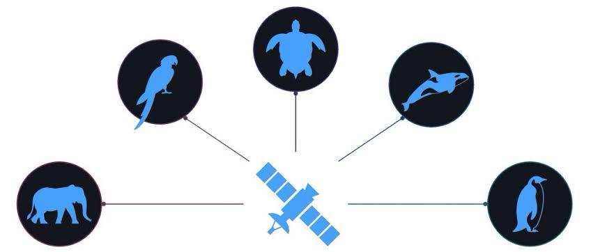
1.3 Satellite Telemetry and GPS Tracking
Modern satellites also enable GPS tracking of individual animals fitted with collars or tags. This allows precise, continuous monitoring of movements, behavior, and even physiological data. For instance, satellite tags on sea turtles help researchers track their oceanic journeys and nesting sites, providing valuable insights into their life cycles.
Sensor Technologies Enhancing Wildlife Mapping
2.1 Camera Traps and Motion Sensors
Camera traps triggered by motion sensors capture photos or videos of wildlife without human presence, reducing disturbance. These devices help monitor elusive or nocturnal species, providing data on species presence, behavior, and population density. Networks of camera traps can cover large areas, feeding data into centralized databases for analysis.
2.2 Acoustic Sensors and Bioacoustics
Some animals are more easily detected through their vocalizations than by sight. Acoustic sensors can record animal sounds over long periods, enabling identification and monitoring of species like birds, bats, and amphibians. Analysis of sound patterns can also indicate population health and diversity.
2.3 Environmental DNA (eDNA) Sensors
Emerging sensor technologies can detect traces of DNA shed by animals into water, soil, or air. This method, called environmental DNA sampling, allows detection of species presence even if individuals are not directly observed. eDNA sensors enhance monitoring of aquatic and terrestrial species with minimal disturbance.
2.4 Drones and Unmanned Aerial Vehicles (UAVs)
Drones equipped with cameras and sensors offer a flexible and relatively low-cost method to collect high-resolution imagery and environmental data. They can access hard-to-reach areas, map habitat conditions, and observe wildlife behavior from above. Combining drones with thermal sensors also helps locate animals in dense vegetation or at night.
Data Integration and Wildlife Mapping Platforms
3.1 Geographic Information Systems (GIS)
GIS platforms integrate satellite imagery, sensor data, and field observations to create detailed wildlife distribution maps. These spatial tools allow researchers to analyze habitat suitability, identify threats, and prioritize conservation areas. They also facilitate scenario modeling to predict how changes in the environment might impact species.
3.2 Artificial Intelligence and Machine Learning
The vast amount of data collected through satellites and sensors can be overwhelming. AI and machine learning algorithms are increasingly used to analyze images, sounds, and movement patterns efficiently. These technologies can automatically identify species from camera trap photos or acoustic recordings, detect poaching activity, and forecast population trends.
3.3 Citizen Science and Crowdsourcing
Mobile apps and online platforms enable the public to contribute wildlife observations, photos, and sensor data. This crowdsourced information supplements satellite and sensor data, broadening coverage and engaging communities in conservation efforts.
Case Studies: Successful Applications of Technology in Wildlife Conservation
4.1 Tracking African Elephants Using GPS and Satellites
African elephants have been fitted with GPS collars transmitting location data via satellites. This technology helps monitor their movements to reduce human-wildlife conflict by alerting communities and authorities when elephants approach farms or villages. The data also assist in identifying migratory corridors and poaching hotspots.
4.2 Monitoring Orangutan Habitats with Satellite Imagery
Satellite data has been used to track deforestation in Borneo, which threatens orangutan habitats. By mapping habitat loss over time, conservationists have prioritized areas for protection and restoration, leading to better-targeted interventions.
4.3 Acoustic Sensors for Monitoring Bird Populations
In tropical rainforests where visual monitoring is difficult, acoustic sensors have been deployed to record bird songs and calls. This method has revealed previously unknown species presence and helped assess the impact of habitat degradation on bird diversity.
Challenges and Limitations
5.1 Technical and Financial Constraints
Deploying satellite-based and sensor technologies can be expensive and technically demanding. High-resolution satellite data often comes at a cost, and sensor networks require maintenance and data management expertise.
5.2 Data Privacy and Ethical Considerations
Tracking animals raises ethical questions, especially with endangered species. Tags and sensors must be carefully designed to minimize stress or harm. Additionally, data privacy concerns arise if conservation efforts intersect with indigenous lands or communities.
5.3 Environmental and Ecological Complexity
While technology provides valuable data, interpreting this information in ecological contexts remains challenging. Wildlife behavior is complex and influenced by numerous factors that remote sensing cannot always capture fully.
The Future of Wildlife Mapping and Conservation
The future promises even greater integration of satellite, sensor, and AI technologies. Innovations such as miniaturized bio-loggers, real-time data streaming, and improved sensor sensitivity will expand the scope and precision of wildlife monitoring.
Moreover, enhanced international collaboration and open data sharing will enable global conservation networks to respond more rapidly to threats. Combining technology with traditional ecological knowledge and community engagement will lead to more sustainable and effective conservation strategies.
The use of cutting-edge technology in wildlife conservation has dramatically transformed the ways researchers and conservationists understand and protect biodiversity, with satellites and sensors playing pivotal roles in this evolution; traditionally, wildlife mapping relied on laborious fieldwork involving direct observations, manual tracking, and localized surveys, which, despite their value, posed significant limitations in terms of geographic scope, data accuracy, and potential disturbance to animals, thereby necessitating more innovative, scalable, and less intrusive methods—this is where satellite remote sensing has emerged as a game changer by offering high-resolution, repeatable, and large-scale monitoring capabilities that enable the observation of ecosystems and habitats from a global perspective, allowing scientists to detect changes in land use, deforestation rates, water availability, and habitat fragmentation that directly affect wildlife populations, as exemplified by the monitoring of the Amazon rainforest where satellite imagery helps track the loss of crucial habitats for species like jaguars and tapirs; beyond habitat monitoring, satellites equipped with GPS and telemetry technologies facilitate precise tracking of individual animals over vast distances, an advancement particularly valuable for migratory species such as sea turtles, elephants, and various bird species, allowing conservationists to map migration corridors, identify critical breeding or feeding grounds, and understand movement patterns essential for effective protection strategies; simultaneously, ground-based sensor technologies, including camera traps and motion sensors, have revolutionized wildlife detection by providing a non-invasive means to capture images and videos of elusive, nocturnal, or shy animals that are difficult to observe otherwise, with networks of these sensors generating extensive datasets that reveal not only species presence but also behaviors, population densities, and interactions within ecosystems—additionally, acoustic sensors contribute a unique dimension to wildlife monitoring by recording vocalizations of species such as birds, frogs, and bats, which are often more easily detected through sound than sight, enabling the identification of species presence and diversity even in dense forests or remote areas where visual surveys are impractical; further complementing these tools, environmental DNA (eDNA) sampling represents a revolutionary technique whereby traces of DNA shed by animals into the environment, such as water bodies or soil, are collected and analyzed to confirm species presence without the need for physical sightings, thus broadening the scope of biodiversity assessment, especially in aquatic ecosystems where many species remain hidden; drones, or unmanned aerial vehicles (UAVs), equipped with high-resolution cameras and thermal imaging sensors, offer flexible, rapid, and cost-effective methods to map habitats, detect poaching activity, and observe wildlife behaviors from perspectives previously unavailable, enabling access to rugged or sensitive areas with minimal disturbance; the integration of these diverse data streams is facilitated through Geographic Information Systems (GIS) and sophisticated data platforms that enable the synthesis of spatial data with sensor outputs and ecological observations, thus creating dynamic, detailed maps that inform conservation decisions, habitat suitability models, and threat assessments; given the enormous volume and complexity of data generated by satellites, sensors, and field studies, artificial intelligence (AI) and machine learning algorithms have become indispensable tools for automating species identification, pattern recognition, and predictive modeling, accelerating data processing and enhancing the accuracy and utility of conservation insights; for example, AI can analyze thousands of camera trap photos to distinguish species and behaviors or detect illegal activities like poaching in near real-time, thus enabling faster response and protection measures; while these technologies offer unprecedented opportunities, several challenges remain, including the high costs and technical expertise required for deploying and maintaining sophisticated sensor networks and satellite data acquisition, the ethical considerations of tagging and tracking wildlife to minimize animal stress or harm, and the complexity of interpreting ecological data that must account for multifaceted environmental variables and animal behaviors; furthermore, concerns around data privacy arise when monitoring overlaps with indigenous lands and sensitive human-wildlife conflict zones, requiring careful collaboration and respect for local communities; nonetheless, successful applications abound, such as the GPS tracking of African elephants that helps reduce human-wildlife conflicts by alerting communities and authorities to elephant movements near farms, or the use of satellite imagery in Borneo to monitor deforestation threatening orangutan populations, guiding conservation priorities and reforestation efforts; acoustic monitoring in tropical rainforests has uncovered previously unknown bird species and provided insights into how habitat degradation affects avian diversity, illustrating the power of technology to reveal hidden biodiversity; looking ahead, the future of wildlife mapping promises even greater integration of miniaturized bio-logging devices, real-time data streaming, and advanced sensor sensitivity that will further refine our understanding of animal ecology, migration, and responses to climate change, supported by enhanced international cooperation and open data platforms that foster global conservation efforts; crucially, these technological advancements must be paired with community engagement, traditional ecological knowledge, and ethical stewardship to ensure that conservation interventions are effective, culturally appropriate, and sustainable; in summary, the convergence of satellite technology, sensor networks, AI, and participatory approaches has ushered in a new era of wildlife mapping that offers unparalleled spatial and temporal detail, enabling more proactive and informed conservation strategies essential to safeguarding biodiversity amidst escalating environmental challenges.
The advancement of technology over the past few decades has fundamentally transformed the field of wildlife conservation, particularly through the integration of satellite technology and sensor networks that allow for comprehensive, precise, and non-invasive mapping of wildlife populations and their habitats, marking a significant departure from the traditional methods of wildlife monitoring that largely depended on direct observation, manual tracking, and limited field surveys which were often labor-intensive, geographically restricted, and sometimes intrusive to the very animals they aimed to study and protect. Satellite remote sensing, in particular, has emerged as a cornerstone in modern conservation efforts, providing researchers with a unique vantage point to monitor vast and often inaccessible areas of the Earth’s surface, offering detailed, high-resolution imagery that can reveal critical information about the state of ecosystems, the extent of forest cover, the health of vegetation, the presence of water bodies, and ongoing land-use changes, all of which directly impact wildlife habitats and thus the survival and behavior of numerous species worldwide; for example, the Amazon rainforest, known as one of the most biodiverse places on Earth, has been closely monitored using satellite imagery to track deforestation rates, habitat fragmentation, and the encroachment of human activities, enabling conservationists to assess threats to species such as jaguars, tapirs, and numerous bird species that rely on continuous tracts of forest for their survival. Beyond just mapping static habitat features, satellites have revolutionized the understanding of animal movement patterns through GPS telemetry, where animals are fitted with GPS-enabled collars or tags that transmit their precise locations via satellite in near real-time, allowing scientists to track migratory routes, breeding grounds, feeding areas, and even behavioral patterns across large spatial scales that were previously impossible to monitor; this technology has been crucial for conserving wide-ranging species such as African elephants, whose movement corridors often cross human settlements, leading to potential conflicts, or sea turtles, whose oceanic journeys from nesting beaches to feeding grounds span thousands of kilometers across international waters. Complementing satellites, sensor technologies deployed at ground level, such as camera traps equipped with motion sensors, have become indispensable tools for wildlife monitoring, as they can capture photographs and videos of animals without the need for human presence, significantly reducing disturbance and allowing the collection of data on species that are elusive, nocturnal, or inhabit dense vegetation where visibility is limited; these camera trap networks, often deployed in strategic locations such as watering holes, trails, or nesting sites, generate vast amounts of data that provide insights into species presence, population density, inter-species interactions, and even rare behaviors, contributing to the understanding of biodiversity in both protected and unprotected areas. In addition to visual sensors, acoustic monitoring devices have expanded the possibilities for wildlife detection by capturing the vocalizations and sounds produced by animals, which is especially valuable for species that are difficult to observe visually, such as many birds, amphibians, and bats; acoustic data allow researchers to identify species presence, monitor seasonal changes in populations, and assess the impact of habitat degradation and noise pollution on animal communication and behavior, with advances in sound analysis software and machine learning enabling automated species recognition from hours of recordings. Another emerging frontier in wildlife mapping is environmental DNA (eDNA) technology, which involves collecting samples from soil, water, or air to detect genetic material shed by organisms, offering a revolutionary non-invasive method to ascertain species presence and diversity even without physical sightings or captures; this is particularly impactful for aquatic environments where many species are cryptic or difficult to monitor, enabling conservationists to detect endangered or invasive species early and to better understand ecosystem health. Meanwhile, the deployment of drones or unmanned aerial vehicles (UAVs) equipped with high-resolution cameras, infrared sensors, and thermal imaging has added a highly flexible and cost-effective tool to conservationists’ arsenals, enabling them to survey difficult terrain, map habitat changes, monitor wildlife populations, and detect illegal activities such as poaching or logging with minimal disturbance and at unprecedented spatial and temporal scales. The integration and management of the enormous volume of data generated by satellites, sensors, drones, and field observations are facilitated by Geographic Information Systems (GIS), which allow for the visualization, spatial analysis, and modeling of wildlife habitats and population dynamics, providing crucial information for conservation planning, protected area design, and threat mitigation; further augmented by artificial intelligence and machine learning, these systems can process and analyze large datasets to automatically identify species from images and sounds, predict migration patterns, detect poaching events, and forecast population changes under different environmental scenarios. However, despite these remarkable advancements, challenges persist, including the high costs of deploying and maintaining technology, the need for specialized technical skills and data management capacity, the ethical implications of tagging and tracking wildlife to minimize stress or harm, and the complexities involved in interpreting data in ecologically meaningful ways that consider the multifaceted interactions among species and their environments; additionally, issues around data privacy and the involvement of indigenous communities necessitate respectful collaborations to ensure that technological conservation efforts align with social and cultural values and benefit local stakeholders. Nevertheless, numerous successful applications of satellite and sensor technologies have already demonstrated their transformative potential, such as the GPS tracking of African elephants that enables timely interventions to prevent human-wildlife conflict, the use of satellite imagery in Borneo to monitor and mitigate deforestation threatening orangutan habitats, and the deployment of acoustic sensors in tropical rainforests to uncover unknown bird species and understand the effects of habitat degradation on avian diversity. Looking to the future, continued innovations in sensor miniaturization, real-time data transmission, and enhanced sensor sensitivity, combined with growing international collaboration and open-access data sharing platforms, promise to further enhance the effectiveness of wildlife monitoring and conservation efforts, enabling more proactive, adaptive, and holistic strategies that address the accelerating threats posed by climate change, habitat loss, and human activities; critically, the success of these technological advances will depend on integrating them with traditional ecological knowledge, ethical stewardship, and strong community engagement to ensure that conservation initiatives are sustainable, culturally appropriate, and capable of preserving biodiversity for generations to come, ultimately underscoring the profound role that satellites, sensors, and advanced data analytics play in mapping wildlife and shaping a better future for global conservation.
Conclusion
Advances in satellite remote sensing, sensor technology, and data analytics have revolutionized wildlife mapping and conservation. From tracking migratory routes with GPS collars to monitoring elusive species with camera traps and acoustic sensors, these tools provide comprehensive insights into animal behavior and habitat conditions. Geographic Information Systems and AI further enable the integration and analysis of vast datasets, facilitating better decision-making for conservation.
While challenges remain, including technical costs and ethical concerns, the benefits of technology in wildlife conservation are profound. These innovations allow researchers and policymakers to monitor biodiversity at unprecedented scales and detail, enabling proactive interventions to protect endangered species and fragile ecosystems.
The future of wildlife conservation lies in continued technological advancements coupled with community involvement and ethical stewardship. Together, satellites, sensors, and smart data analysis are transforming the way we understand and protect the natural world.
Q&A Section
Q1: How do satellites help in tracking wildlife?
Ans: Satellites provide remote sensing imagery to monitor habitats and environmental changes. Additionally, they enable GPS telemetry to track the movements of animals fitted with satellite-linked collars or tags, allowing researchers to monitor migration routes and behaviors in real-time.
Q2: What are camera traps and why are they important?
Ans: Camera traps are motion-activated cameras used to capture images or videos of wildlife without human presence. They are crucial for monitoring elusive or nocturnal species, gathering data on species diversity, behavior, and population without disturbing animals.
Q3: How does acoustic monitoring contribute to wildlife conservation?
Ans: Acoustic sensors record animal vocalizations, enabling researchers to detect and monitor species that are otherwise hard to observe visually, such as birds, bats, and amphibians. This helps in assessing population health and biodiversity in dense habitats.
Q4: What challenges do researchers face using these technologies?
Ans: Challenges include high costs, technical expertise required, data management complexity, ethical concerns regarding animal welfare, and difficulties in interpreting ecological data accurately.
Q5: How can AI improve wildlife monitoring?
Ans: AI can automatically analyze large datasets from images and sounds to identify species, detect patterns, and predict trends. This improves the efficiency and accuracy of wildlife monitoring and helps in rapid response to threats.
Similar Articles
Find more relatable content in similar Articles

The Future of Electric Planes ..
The aviation industry is under.. Read More

Virtual Reality Therapy: Heali..
Virtual Reality Therapy (VRT) .. Read More

E-Waste Crisis: The Race to Bu..
The rapid growth of electronic.. Read More

3D-Printed Organs: Are We Clos..
3D-printed organs are at the f.. Read More
Explore Other Categories
Explore many different categories of articles ranging from Gadgets to Security
Smart Devices, Gear & Innovations
Discover in-depth reviews, hands-on experiences, and expert insights on the newest gadgets—from smartphones to smartwatches, headphones, wearables, and everything in between. Stay ahead with the latest in tech gear
Apps That Power Your World
Explore essential mobile and desktop applications across all platforms. From productivity boosters to creative tools, we cover updates, recommendations, and how-tos to make your digital life easier and more efficient.
Tomorrow's Technology, Today's Insights
Dive into the world of emerging technologies, AI breakthroughs, space tech, robotics, and innovations shaping the future. Stay informed on what's next in the evolution of science and technology.
Protecting You in a Digital Age
Learn how to secure your data, protect your privacy, and understand the latest in online threats. We break down complex cybersecurity topics into practical advice for everyday users and professionals alike.
© 2025 Copyrights by rTechnology. All Rights Reserved.