From GPS Collars to Drones: Tracking Wildlife in the Tech Age.
Exploring the evolution of wildlife tracking technologies, this article examines how GPS collars and drones have revolutionized conservation efforts by providing accurate, real-time data on animal movements and behaviors. Highlighting key applications, ethical considerations, and future innovations, it showcases the transformative impact of tech in understanding and protecting wildlife, ultimately enhancing global efforts to preserve biodiversity and mitigate human-wildlife conflicts.
✨ Raghav Jain
Introduction
Wildlife tracking has evolved dramatically over the past few decades. From simple tagging techniques to sophisticated satellite and drone-based surveillance systems, modern technology has revolutionized the way researchers, conservationists, and governments monitor wildlife. These advancements have not only improved our understanding of animal behavior and movement patterns but also enhanced conservation efforts, conflict mitigation, and anti-poaching strategies.
This article explores the historical context, current technologies, practical applications, and ethical implications of wildlife tracking, focusing on innovations like GPS collars and drones that have redefined the possibilities of wildlife research and protection in the 21st century.
A Brief History of Wildlife Tracking
Historically, wildlife tracking involved rudimentary techniques such as:
- Direct Observation: Scientists would follow animals in their natural habitat, often recording behavior manually.
- Tagging and Banding: Metal bands or colored tags were attached to animals (especially birds) for identification and population studies.
- Radio Telemetry: Introduced in the 1960s, radio collars allowed researchers to follow animals using directional antennas.
While these methods provided foundational insights, they were often limited by terrain, manpower, and technology.
GPS Collars: Precision in Motion
One of the most transformative developments in wildlife tracking is the Global Positioning System (GPS) collar. Introduced in the 1990s and continuously refined, GPS collars offer real-time, high-precision location data.
How GPS Collars Work
GPS collars use satellites to determine the location of an animal at regular intervals. This data is stored on the device or transmitted via satellite, GSM, or VHF signals to a central database.
Key Features
- High Accuracy: Pinpoints animal locations within a few meters.
- Data Logging and Transmission: Stores vast quantities of data or sends it in near real-time.
- Customizable Sampling Rates: Records location every few seconds to several hours, depending on need.
- Durability and Battery Life: Designed to withstand harsh environments and last for months to years.
Applications
- Migration Tracking: Understanding the long-distance travel of birds, caribou, or whales.
- Behavioral Studies: Analyzing how predators hunt or how herbivores graze.
- Conservation Management: Identifying critical habitats and corridors.
- Conflict Mitigation: Tracking elephants or big cats to prevent human-wildlife conflict.
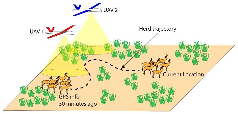
Drone Technology: The Aerial Revolution
Drones, also known as Unmanned Aerial Vehicles (UAVs), represent another leap forward in wildlife tracking and monitoring. Equipped with high-definition cameras, thermal imaging sensors, and AI-powered analytics, drones offer a bird's-eye view of ecosystems.
Benefits of Drones in Wildlife Research
- Non-Invasive Monitoring: Unlike ground-based tracking, drones can observe animals without disturbing them.
- Access to Remote Areas: Easily reach difficult or dangerous terrains like dense forests or mountainous regions.
- Real-Time Surveillance: Stream live video and data for immediate analysis.
- Cost Efficiency: Compared to manned aircraft, drones are more affordable for long-term monitoring.
Common Use Cases
- Nest Surveys: Counting birds or eggs in inaccessible nesting sites.
- Population Estimation: Assessing the number of individuals in a herd or flock.
- Anti-Poaching Patrols: Real-time monitoring of protected areas.
- Habitat Mapping: Using aerial imagery for land cover classification and ecological modeling.
Combining Technologies: Integrated Tracking Systems
Modern wildlife tracking efforts increasingly rely on multi-modal data collection, combining GPS collars, drones, camera traps, and satellite imagery.
Examples of Integrated Systems
- SMART Collars: Combine GPS, accelerometers, and health sensors to monitor movement and well-being.
- Drone-GPS Synergy: Drones can be deployed based on real-time GPS collar data to observe specific behaviors or alert researchers to anomalies.
- AI and Big Data: Machine learning models analyze movement patterns, predict behaviors, or detect signs of distress.
This integration enhances decision-making and enables predictive conservation strategies, such as determining where animals might move based on environmental factors.
Ethical Considerations and Challenges
With the power of advanced tracking technologies comes responsibility. Ethical and practical challenges include:
Animal Welfare
- Devices must be designed to avoid discomfort, injury, or behavioral disruption.
- Lightweight and ergonomically tested designs are essential.
Privacy and Surveillance
- In some regions, drones or GPS devices may inadvertently capture human activity, raising privacy concerns.
Data Security
- Sensitive location data (e.g., rhino positions) must be protected from poachers or malicious actors.
Regulatory Issues
- Countries may have specific laws regarding drone flights or wildlife tracking permits.
Addressing these concerns is critical for the sustainable and ethical use of technology in conservation.
Success Stories and Global Examples
1. Snow Leopards in the Himalayas
GPS collars have provided insights into the elusive behavior and vast home ranges of snow leopards, helping to mitigate conflict with local herders.
2. African Elephants
GPS tracking has helped reduce human-elephant conflict by alerting communities when elephants approach farmlands. Drones complement this system by monitoring herd movement in real-time.
3. Sea Turtle Migrations
Satellite tags and drones have mapped sea turtle nesting beaches and migratory routes, aiding in marine conservation policies.
4. Amazon Rainforest Surveillance
Drones are increasingly used to monitor illegal logging and poaching activities while mapping wildlife populations in hard-to-access jungle areas.
Future Prospects
The future of wildlife tracking is poised to benefit from several technological trends:
- Miniaturization: Lighter, smaller devices will allow tagging of smaller species like insects or small birds.
- Solar-Powered Devices: Extend operational life without battery replacement.
- AI-Powered Behavior Prediction: Anticipate migration, breeding, or stress behavior.
- Blockchain for Data Security: Ensures tamper-proof data logs.
In the ever-evolving relationship between humanity and the natural world, few developments have been as transformative as the integration of advanced technologies into wildlife tracking, ushering in a new era of conservation science marked by precision, real-time data, and unprecedented insights into the lives of wild animals. Traditionally, wildlife researchers relied on labor-intensive and often intrusive methods such as tagging, direct observation, or radio telemetry, which, while foundational, were limited by scope, terrain, and the unpredictability of animal behavior. The advent of GPS collars in the 1990s marked a monumental shift, allowing researchers to remotely monitor animal movements with remarkable accuracy, often down to a few meters, and collect data continuously over months or years. These collars, powered by satellite systems and often equipped with accelerometers, temperature sensors, and even cameras, not only track an animal’s location but also help interpret behaviors such as hunting, mating, or resting, offering invaluable data for understanding migratory patterns, identifying critical habitats, and developing strategies to reduce human-wildlife conflicts, such as alerting communities when elephants approach farmland. Simultaneously, drone technology, or unmanned aerial vehicles (UAVs), emerged as a complementary tool, enabling aerial surveys that are both cost-effective and minimally invasive, capable of accessing remote or rugged terrain that would otherwise be difficult for humans to navigate. Equipped with high-resolution cameras, thermal imaging, and even AI-based detection software, drones are now widely used for a multitude of applications: from counting animal populations in vast savannahs to detecting illegal poaching activity in real time, monitoring habitat loss, and even observing the nesting habits of rare bird species in inaccessible cliffs or tree canopies. These technologies not only reduce the risk of disturbing wildlife but also offer conservationists the ability to act swiftly when danger arises. In some regions, integrated systems have been developed that use real-time GPS collar data to direct drones to specific locations, creating dynamic monitoring systems capable of responding to rapidly changing field conditions. Moreover, the role of artificial intelligence and big data analytics has become increasingly significant, as massive datasets generated by GPS collars, drones, and camera traps are analyzed to detect patterns, predict animal movements, and make informed decisions for species protection. Such systems can, for instance, predict the likely movements of endangered animals like snow leopards or African wild dogs, enabling preemptive conservation action or human-wildlife conflict mitigation. Innovations continue to expand the horizon of what is possible—miniaturization has made it feasible to track even small birds and amphibians, solar-powered collars extend the lifespan of tracking devices, and machine learning algorithms refine the accuracy of population estimates from drone footage. Despite the promise of these technologies, ethical and logistical challenges persist; the welfare of animals remains paramount, necessitating that tracking devices be lightweight, non-invasive, and durable under natural conditions, while data security is critical, especially when tracking high-value species vulnerable to poaching, such as rhinos or tigers. Legal frameworks and cultural sensitivities must also be considered, particularly with drone flights that might capture human activity inadvertently or interfere with local customs and wildlife policies. Furthermore, while these tools offer immense benefits, they are not standalone solutions; their effectiveness depends on skilled personnel, local engagement, adequate funding, and collaboration across scientific, governmental, and indigenous communities. Numerous success stories underscore the power of tech-driven conservation: GPS tracking has helped restore wolf populations in Yellowstone, drones have been deployed to halt poaching in Africa’s protected areas, and satellite data has guided marine protected area designations by tracking turtle and shark migrations across international waters. These case studies demonstrate that when deployed thoughtfully and ethically, technology does not separate us from nature but draws us closer to it, enabling a deeper understanding and a more proactive stewardship of Earth's biodiversity. As climate change accelerates and human development pressures grow, the integration of GPS collars, drones, and AI into wildlife monitoring is not just a luxury but a necessity—a vital tool in ensuring the survival of species, the preservation of ecosystems, and the balance of life on our planet. The future of wildlife tracking promises even more interconnectivity: blockchain technology may soon secure wildlife data against tampering, satellite imagery integrated with drone surveillance may offer real-time global wildlife movement maps, and citizen science platforms could allow local communities to participate in tracking efforts through mobile apps and sensor networks. As this technological evolution unfolds, the challenge will be not just to innovate, but to do so ethically, inclusively, and sustainably, ensuring that the digital tools of the modern age remain aligned with the ancient rhythms of the natural world they seek to protect.
In the modern era, the way humans study and conserve wildlife has undergone a profound transformation thanks to the advent and integration of cutting-edge technology such as GPS collars and drones, which have revolutionized wildlife tracking by providing unparalleled precision, real-time monitoring capabilities, and the ability to collect massive amounts of data with minimal disturbance to the animals themselves, thus enabling researchers, conservationists, and policymakers to gain deeper insights into animal behavior, migration patterns, habitat use, and population dynamics than ever before. Historically, wildlife tracking relied on relatively rudimentary methods such as tagging, banding, and manual observation, which were often time-consuming, limited in spatial and temporal scope, and sometimes invasive to the animals. The introduction of radio telemetry in the mid-20th century provided some advancements, allowing researchers to follow animals remotely using radio signals; however, this method still required close-range tracking and intensive fieldwork. The true breakthrough came with the emergence of GPS technology in the 1990s, which harnessed satellite signals to pinpoint animal locations with incredible accuracy and allowed data to be transmitted remotely over vast distances, transforming wildlife research into a high-tech science that could generate detailed movement datasets continuously over months or even years. GPS collars, designed to be lightweight, durable, and equipped with sensors that can record not only location but also acceleration, temperature, and other physiological metrics, have been deployed across a wide array of species — from the largest elephants and wolves to smaller mammals and even some birds — facilitating critical research that informs conservation strategies, such as identifying migration corridors, detecting seasonal habitat preferences, and understanding social structures within populations. The real-time data obtained through GPS collars also enables rapid response to emergent threats, such as approaching poachers or environmental hazards, and can reduce human-wildlife conflicts by alerting local communities when potentially dangerous animals, like elephants or big cats, move into farmland or villages. Meanwhile, drone technology, or unmanned aerial vehicles, has emerged as a powerful complementary tool, providing aerial surveillance capabilities that are both cost-effective and minimally invasive, capable of accessing challenging terrains like dense forests, mountainous areas, or wetlands that are difficult or dangerous for humans to reach. Equipped with high-resolution optical cameras, thermal imaging sensors, and sometimes even LiDAR technology, drones can capture detailed imagery for population counts, habitat mapping, and monitoring of behavioral events such as breeding or hunting, all while minimizing disturbance to the animals under observation. Drones also play a critical role in anti-poaching operations, patrolling protected areas and detecting suspicious activities in real time, thus significantly enhancing the effectiveness of ranger teams. The integration of these technologies is driving a paradigm shift, where multi-modal data collection and advanced analytics powered by artificial intelligence allow for a holistic understanding of wildlife ecology, improving predictive models that can forecast animal movements and potential conflicts with humans, thereby informing proactive conservation interventions. Moreover, advancements in miniaturization have enabled the deployment of GPS and other sensors on smaller animals, such as songbirds and amphibians, expanding the range of species that can be monitored and offering new insights into ecosystem dynamics at multiple scales. Despite these tremendous advances, challenges remain, including ensuring animal welfare by designing tracking devices that do not impede natural behavior or cause injury, addressing concerns about privacy and data security, especially in areas where sensitive location data could be exploited by poachers, navigating legal regulations around drone use and wildlife research permits, and securing sufficient funding and local stakeholder engagement to sustain long-term monitoring programs. Importantly, the ethical use of these technologies requires transparent communication with local communities, respect for indigenous knowledge systems, and careful balancing of technological benefits against potential ecological and social impacts. Successful applications abound worldwide: for instance, GPS collars have been instrumental in studying elusive species like snow leopards in the Himalayas, revealing previously unknown movement patterns that have informed protected area design; drones have been deployed in the Amazon to monitor biodiversity and detect illegal logging, combining ecological research with forest conservation enforcement; in African savannahs, integrated GPS-drone systems have helped reduce human-elephant conflicts by providing timely alerts and enabling targeted interventions; and satellite tags on sea turtles have uncovered migratory routes that cross international waters, guiding multinational conservation agreements. Looking ahead, the future of wildlife tracking is promising, with ongoing technological innovations such as solar-powered devices that extend battery life indefinitely, AI-driven image and movement analysis that reduce the need for manual data processing, blockchain technology to secure and verify data integrity, and expanded citizen science initiatives that empower local populations to participate in wildlife monitoring through smartphone apps and low-cost sensors. These developments promise to democratize conservation efforts and foster greater global collaboration in preserving biodiversity amidst mounting environmental threats such as climate change, habitat fragmentation, and poaching. In essence, the fusion of GPS collars, drones, and data science represents a powerful toolkit that not only enhances our scientific understanding of wildlife but also deepens our capacity to protect and coexist with the natural world, illustrating how technology—when thoughtfully and ethically applied—can serve as a bridge between humans and the complex ecosystems that sustain life on Earth, offering hope for the future of many endangered species and the health of global biodiversity.
Conclusion
As biodiversity faces increasing threats from climate change, habitat loss, and human encroachment, leveraging technology has become indispensable. GPS collars and drones symbolize the cutting edge of wildlife science, but they also remind us of the responsibility we bear in using them wisely. With ongoing innovation, cross-disciplinary collaboration, and ethical foresight, the tech age offers unprecedented hope for the planet’s wildlife.
Q&A Section
Q1: - What are the main advantages of using GPS collars in wildlife tracking?
Ans: - GPS collars provide accurate, real-time data on animal locations, movement patterns, and behavior. They help in migration studies, conflict mitigation, and conservation planning with minimal human interference.
Q2: - How do drones complement traditional tracking methods?
Ans: - Drones offer aerial surveillance, access to remote areas, and real-time video. They are non-invasive and can quickly cover large areas, making them ideal for population counts, habitat mapping, and anti-poaching efforts.
Q3: - Are there ethical concerns in using technology to track wildlife?
Ans: - Yes, ethical concerns include potential harm to animals from improperly designed devices, invasion of privacy (for both animals and humans), and data security, especially in poaching-prone regions.
Q4: - Can GPS collars be used on small animals?
Ans: - While early collars were too bulky for small species, advances in miniaturization have allowed GPS devices to be used on smaller mammals and even birds. Further innovations continue to reduce size and weight.
Q5: - What is the role of artificial intelligence in wildlife tracking?
Ans: - AI is used to analyze large datasets from GPS, drones, and camera traps. It can detect patterns, predict behaviors, and identify threats, enhancing both research outcomes and conservation response times.
Similar Articles
Find more relatable content in similar Articles

3D-Printed Organs: Are We Clos..
3D-printed organs are at the f.. Read More

E-Waste Crisis: The Race to Bu..
The rapid growth of electronic.. Read More

The Future of Electric Planes ..
The aviation industry is under.. Read More

Virtual Reality Therapy: Heali..
Virtual Reality Therapy (VRT) .. Read More
Explore Other Categories
Explore many different categories of articles ranging from Gadgets to Security
Smart Devices, Gear & Innovations
Discover in-depth reviews, hands-on experiences, and expert insights on the newest gadgets—from smartphones to smartwatches, headphones, wearables, and everything in between. Stay ahead with the latest in tech gear
Apps That Power Your World
Explore essential mobile and desktop applications across all platforms. From productivity boosters to creative tools, we cover updates, recommendations, and how-tos to make your digital life easier and more efficient.
Tomorrow's Technology, Today's Insights
Dive into the world of emerging technologies, AI breakthroughs, space tech, robotics, and innovations shaping the future. Stay informed on what's next in the evolution of science and technology.
Protecting You in a Digital Age
Learn how to secure your data, protect your privacy, and understand the latest in online threats. We break down complex cybersecurity topics into practical advice for everyday users and professionals alike.
© 2025 Copyrights by rTechnology. All Rights Reserved.